


Bugaboo Provincial Park
Vous pensez qu'il y a une erreur sur ce lieu ?
Signaler une erreur
Vos retours sont importants pour nous. Si vous avez remarqué une erreur concernant ce lieu, merci de nous en informer pour que nous puissions la corriger.
Propriétaire de ce lieu ?
Nous récupérons automatiquement les informations disponibles sur votre lieu. Si jamais celles-ci ne sont pas correctes, connectez-vous gratuitement sur notre tableau de bord pour les modifier et bonus, accédez à vos statistiques détaillées.
Ce qu'en disent les utilisateurs
Autres lieux à voir autour
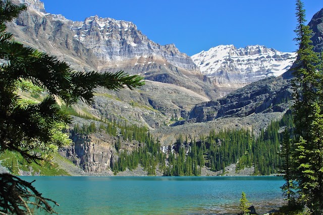
 Lac Moraine
, District d'amélioration No 9, AB T0L, Canada
Ajouté par672 utilisateurs
Lac Moraine
Lac Moraine, District d'amélioration No 9, AB T0L, Canada
Ajouté par672 utilisateurs
 Banff
Banff, AB, Canada
Ajouté par417 utilisateurs
Banff
Banff, AB, Canada
Ajouté par417 utilisateurs
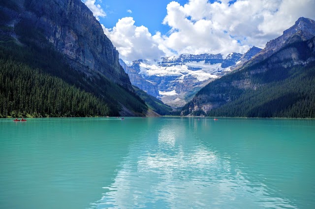 Lake Louise
, AB, Canada
Ajouté par370 utilisateurs
Lake Louise
Lake Louise, AB, Canada
Ajouté par370 utilisateurs
 Lac Peyto
, District d'amélioration No 9, AB T0L, Canada
Ajouté par327 utilisateurs
Lac Peyto
Lac Peyto, District d'amélioration No 9, AB T0L, Canada
Ajouté par327 utilisateurs
 Parc national de Banff
Alberta T0L, Canada
Ajouté par318 utilisateurs
Parc national de Banff
Alberta T0L, Canada
Ajouté par318 utilisateurs
 Lac Emerald
, Columbia-Shuswap A, BC V0A, Canada
Ajouté par266 utilisateurs
Lac Emerald
Lac Emerald, Columbia-Shuswap A, BC V0A, Canada
Ajouté par266 utilisateurs
 Johnston Canyon Hiking Area
Bow Valley Pkwy, Improvement District No. 9, AB T0L, Canada
Ajouté par181 utilisateurs
Johnston Canyon Hiking Area
Bow Valley Pkwy, Improvement District No. 9, AB T0L, Canada
Ajouté par181 utilisateurs
 Parc national du Canada Yoho
Field, BC V0A 1G0, Canada
Ajouté par178 utilisateurs
Parc national du Canada Yoho
Field, BC V0A 1G0, Canada
Ajouté par178 utilisateurs
 Lac Bow
, District d'amélioration No 9, AB T0L, Canada
Ajouté par146 utilisateurs
Moraine Lake-Banff National Park
Moraine Lake Rd Alberta T0L Canada
Ajouté par138 utilisateurs
Lac Bow
Lac Bow, District d'amélioration No 9, AB T0L, Canada
Ajouté par146 utilisateurs
Moraine Lake-Banff National Park
Moraine Lake Rd Alberta T0L Canada
Ajouté par138 utilisateurs
"Conrad Kain Hut Length one-way: 5km Suggested hiking time: 1.5-3hrs Elevation change: 700m This trail, which begins in the parking lot, follows the northern lateral moraine of Bugaboo Glacier. The trail is very steep and strenuous, with exposure to steep drop-offs as it climbs through granite bluffs. Extreme caution should be exercised along its route. Strong, reliable footwear is essential. Cobalt Lake Length one-way: 8.5km Suggested hiking time: 2-4hrs Elevation change: 800m This trail, which begins along the park access road across from the CMH Lodge, begins by climbing a series of steep switchbacks up an old skid road, followed by a trail through a forest of alpine larch trees. It eventually leads to an open alpine ridge with good views to Cobalt Lake and the Bugaboo Spires. To reach the lake, descend off the ridge to an alpine pass and contour under Northpost Spire to below the waterfalls draining Cobalt Lake. Bypass the waterfalls on the left to reach the meadows surrounding the lake. Note that the last two kilometres of trail to the lake requires route-finding skills as it is infrequently marked. The un-marked alpine traverse route between Cobalt Lake and the Conrad Kain Hut crosses talus slopes, snowfields, and a small-but-crevassed glacier. It should only be attempted by those with appropriate skills and experience. Malloy Igloo Length one-way: 13km. Elevation change: 762m This demanding mountaineering excursion begins at the Conrad Kain Hut (which is the starting point for many routes that lead to climbing destinations) and terminates at the Malloy Igloo, a small shelter with no amenities located near Osprey Peak. Only roped parties should attempt this route because several glaciers have to be crossed. Alternatively, access to the Malloy Igloo via Malloy Creek is possible. For groups of mixed experience, it poses several obstacles. It is recommended that you stay on the east side of the creek due to two formidable stream crossings, and gain access via a small, steep gully from which the crest of the moraine can be reached. The final headwall is easier in early summer (there is lots of snow), but may require roped climbing later in the season."
@katde.wey