


Vous pensez qu'il y a une erreur sur ce lieu ?
Signaler une erreur
Vos retours sont importants pour nous. Si vous avez remarqué une erreur concernant ce lieu, merci de nous en informer pour que nous puissions la corriger.
Propriétaire de ce lieu ?
Nous récupérons automatiquement les informations disponibles sur votre lieu. Si jamais celles-ci ne sont pas correctes, connectez-vous gratuitement sur notre tableau de bord pour les modifier et bonus, accédez à vos statistiques détaillées.
Ce qu'en disent les utilisateurs
Autres lieux à voir autour
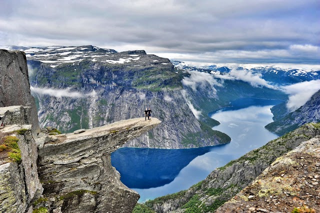 Trolltunga
Odda, Norvège
Ajouté par278 utilisateurs
Trolltunga
Odda, Norvège
Ajouté par278 utilisateurs
 Trolltunga
, Odda, Norvège
Ajouté par225 utilisateurs
Trolltunga
Trolltunga, Odda, Norvège
Ajouté par225 utilisateurs
 Vøringfossen
Eidfjord, Norvège
Ajouté par196 utilisateurs
Vøringfossen
Eidfjord, Norvège
Ajouté par196 utilisateurs
 Trolltunga Active
Skjeggedal 20, 5770 Tyssedal, Norvège
Ajouté par116 utilisateurs
Trolltunga Active
Skjeggedal 20, 5770 Tyssedal, Norvège
Ajouté par116 utilisateurs
 Hardangerdykk
Stanavegen 5770 Tyssedal Norway
Ajouté par187 utilisateurs
Hardangerdykk
Stanavegen 5770 Tyssedal Norway
Ajouté par187 utilisateurs
 Låtefossen Waterfall
Låtefossen, 5763 Odda, Norvège
Ajouté par131 utilisateurs
Låtefossen Waterfall
Låtefossen, 5763 Odda, Norvège
Ajouté par131 utilisateurs
 Flåmsbana / the Flam Railway
Flam - Norway, 5742 Flåm, Norvège
Ajouté par135 utilisateurs
Flåmsbana / the Flam Railway
Flam - Norway, 5742 Flåm, Norvège
Ajouté par135 utilisateurs
 Hardangervidda National Park
Eidfjord, Norvège
Ajouté par62 utilisateurs
Hardangervidda National Park
Eidfjord, Norvège
Ajouté par62 utilisateurs
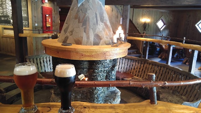 Ægir microbrewery
Flåmsbrygga, 5742 Flåm, Norvège
Ajouté par88 utilisateurs
Ægir microbrewery
Flåmsbrygga, 5742 Flåm, Norvège
Ajouté par88 utilisateurs
 Flåm
Flåm, Norvège
Ajouté par74 utilisateurs
Flåm
Flåm, Norvège
Ajouté par74 utilisateurs
"The scenery and waterfalls in Husedalen simply take your breath away. Four stunning waterfalls are close to each other along the hiking trail from Kinsarvik up to the Hardangervidda mountain plateau. A hike from the car park to the uppermost fall and back takes 5-6 hours. The area is easily accessible and a good alternative for hikes of any length. Hardanger Fossasti (footpath) is a light walk starting in Kinsarvik. Follow the path along the river and read the information boards along the way. More information and map. Starting point Follow the local road signposted Husedalen from route 13 in the centre of Kinsarvik. Shuttlebus Hardanger offers, on request, transportation and pick-up service to/from the starting and ending point of the hiking trail. Booking information, you can find here. About the trail This trail has been known for decades as one of the most beautiful hikes in Norway. Some parts are demanding and steep, slippery when wet. The hike takes you into the Hardangervidda National Park, the largest in Norway. After parking, hike along the gravel road to the first waterfall Tveitafossen. From here there are two options: 1) Follow a partly quite steep trail marked with red Ts, from behind the power station. May be slippery. 2) Follow a steep gravel road that ends before the third waterfall. Continue to the third and fourth waterfall on the T-marked trail. The gravel road is also a nice return path. You may also start hiking in the centre of Kinsarvik, adding an extra 2 km each way. Parking: Near the go-kart circuit and the shooting range, before crossing the river Vivippo. Turn back if you see the helicopter base on the right side. Parking fee: free Length: 5 km (one way), or less if turning back earlier. Total ascent: 700 meters, or less if turning back earlier. Total walking time: 3 - 6 hours (2 waterfalls or 4 waterfalls) Season (average year): May – October "
@wheely