


Palouse Falls State Park
Vous pensez qu'il y a une erreur sur ce lieu ?
Signaler une erreur
Vos retours sont importants pour nous. Si vous avez remarqué une erreur concernant ce lieu, merci de nous en informer pour que nous puissions la corriger.
Propriétaire de ce lieu ?
Nous récupérons automatiquement les informations disponibles sur votre lieu. Si jamais celles-ci ne sont pas correctes, connectez-vous gratuitement sur notre tableau de bord pour les modifier et bonus, accédez à vos statistiques détaillées.
Ce qu'en disent les utilisateurs
Autres lieux à voir autour
Palouse Falls State Park
Palouse Falls Rd, Lacrosse, WA 99143, États-Unis
Ajouté par109 utilisateurs
 Palouse Falls
, Washington 99143, États-Unis
Ajouté par25 utilisateurs
Palouse Falls
Palouse Falls, Washington 99143, États-Unis
Ajouté par25 utilisateurs
 Riverfront Park
507 N Howard St, Spokane, WA 99201, États-Unis
Ajouté par18 utilisateurs
Riverfront Park
507 N Howard St, Spokane, WA 99201, États-Unis
Ajouté par18 utilisateurs
 Atticus Coffee & Gifts
222 N Howard St, Spokane, WA 99201, USA
Ajouté par18 utilisateurs
Atticus Coffee & Gifts
222 N Howard St, Spokane, WA 99201, USA
Ajouté par18 utilisateurs
 Frank's Diner
1516 W 2nd Ave, Spokane, WA 99201, États-Unis
Ajouté par17 utilisateurs
Frank's Diner
1516 W 2nd Ave, Spokane, WA 99201, États-Unis
Ajouté par17 utilisateurs
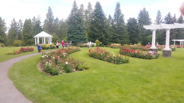 Manito Park
1702 S Grand Blvd, Spokane, WA 99203, États-Unis
Ajouté par14 utilisateurs
Manito Park
1702 S Grand Blvd, Spokane, WA 99203, États-Unis
Ajouté par14 utilisateurs
 Bar Bacetto
119 Main St, Waitsburg, WA 99361, USA
Ajouté par13 utilisateurs
Bar Bacetto
119 Main St, Waitsburg, WA 99361, USA
Ajouté par13 utilisateurs
 Clinkerdagger
621 W Mallon St, Spokane, WA 99201, États-Unis
Ajouté par15 utilisateurs
Clinkerdagger
621 W Mallon St, Spokane, WA 99201, États-Unis
Ajouté par15 utilisateurs
 Steptoe Butte State Park
Whitman, Colfax, WA 99111, États-Unis
Ajouté par12 utilisateurs
Steptoe Butte State Park
Whitman, Colfax, WA 99111, États-Unis
Ajouté par12 utilisateurs
 Aéroport international de Spokane
9000 W Airport Dr, Spokane, WA 99224, États-Unis
Ajouté par14 utilisateurs
Aéroport international de Spokane
9000 W Airport Dr, Spokane, WA 99224, États-Unis
Ajouté par14 utilisateurs
"Saturday, July 09, 2011 12:05:13 AM GMT GPSCoordinates: 46°39'52.596" N 118°13'31.697" W"
@scott.shields.photo.workshops
"Best lid-late afternoon. Shot Friday, July 08, 2011 11:49:24 PM GMT at GPSCoordinates: 46°39'48.905" N 118°13'35.957" W"
@scott.shields.photo.workshops
"Palouse, Washington scenic road trip The Palouse is one of the most underrated scenic drives in the Northwest: rolling wheat fields, old barns, small farming towns, big skies, and overlook roads that feel almost like driving through a painting. It is not dramatic in the “red rock canyon” way; it is more peaceful, wide-open, photographic, and slow-travel oriented. The official Palouse Scenic Byway is not one single road. It is a multi-route scenic region across southeastern Washington, using highways like US 195, WA 27, WA 26, and quieter farm roads. Washington tourism describes it as a drive through rolling hills, farmland, buttes, small towns, Palouse Falls, and the Palouse/Snake River country. Best route For a first Palouse road trip, I’d do this: Spokane → Colfax → Steptoe Butte → Palouse → Pullman → Uniontown → Wawawai / Snake River → Palouse Falls → Spokane That makes it a 2-day loop with the best mix of viewpoints, towns, farm-country driving, and one major waterfall. Best 2-day itinerary Day 1: Spokane to Pullman via Steptoe Butte Start in Spokane and head south on US 195 toward Colfax. From there, make Steptoe Butte your main scenic stop. Steptoe Butte is a National Natural Landmark and gives huge panoramic views over the surrounding farmland, mountains, and states; Washington State Parks lists it as open 8 a.m. to dusk year-round, with Discover Pass/day-use fees. Route: Spokane → Rosalia → Colfax → Steptoe Butte → Palouse → Pullman Best stops: Stop Why it’s worth it Rosalia Small-town Palouse feel and historic remnants Colfax Good base town and gateway to Steptoe Butte Steptoe Butte The must-do overlook; best at sunrise or sunset Palouse, WA Charming small town surrounded by rolling hills Pullman Best overnight base with more hotels and restaurants My take: Steptoe Butte is the one stop I would build the entire trip around. The Palouse Scenic Byway site notes that Steptoe Butte rises about 3,618 feet and offers panoramic views of the region. Day 2: Pullman, backroads, Snake River, Palouse Falls On Day 2, drive the farm roads south and west of Pullman, then continue toward Palouse Falls State Park if you want the big scenic finale. Route: Pullman → Uniontown → Wawawai Road / Snake River → Starbuck / Washtucna area → Palouse Falls → return to Spokane or continue west Best stops: Stop Why it’s worth it Pullman Good food/lodging base; college-town energy Uniontown Quiet farm-town stop south of Pullman Wawawai Road Scenic descent toward the Snake River Snake River viewpoints Big contrast from rolling wheat fields Palouse Falls Dramatic waterfall and one of eastern Washington’s signature sights Palouse Falls is a strong add-on because it gives the route a different kind of visual payoff after the soft farmland scenery. Washington’s byway pages specifically call out Palouse Falls, the Snake River, local history, and small towns as part of the scenic experience. Best time to go Best overall: late May through June That’s when the hills are usually green and lush, especially for photography. Also good: July into early August More golden wheat-field look, warmer, and very pretty. Fall: quieter, more brown/gold, less lush. Winter/spring caution: some roads can be slick or muddy, and visibility/weather can change quickly. For photography, do sunrise or sunset at Steptoe Butte. Midday can look flat; low-angle light makes the hills ripple. How many days? Half-day Only works if you are already in Spokane or Pullman. Do Steptoe Butte + Colfax + nearby farm roads. 1 full day Good, but a bit rushed. Do Spokane → Steptoe Butte → Pullman → Palouse → Spokane. 2 days Best fit. Gives you both Steptoe Butte and Palouse Falls/Snake River without making it feel like a drive-by. 3 days Best for photography. You can do sunrise and sunset sessions, explore backroads, and not worry about weather/light. Bronco / driving notes Your Bronco Sport would be a great fit here, but treat it as a scenic paved-and-gravel-road trip, not an off-road trail trip. Many of the best views are on rural roads, and some may be gravel or farm access roads. Stay on public roads, avoid private farm tracks, and be careful after rain because dirt shoulders and unpaved sections can get soft. The road up Steptoe Butte is paved but narrow and twisty, with exposure and limited room in places. I’d do it slowly, avoid icy/windy conditions, and be extra cautious near sunset when photographers and cars cluster at the top. Where to stay Best base: Pullman Most practical choice, with hotels, restaurants, and easy access to the southern Palouse. Also good: Spokane Better if you want more hotel choices and are doing the Palouse as a day trip. More local/rural: Colfax Convenient for Steptoe Butte, but fewer lodging and dining options. My recommendation For you, I’d make it a 2-night scenic photography-style road trip: Night 1: Spokane Drive in, relax, maybe get an early start. Day 1: Spokane → Colfax → Steptoe Butte → Palouse → Pullman Stay in Pullman. Day 2: Pullman → Uniontown → Wawawai/Snake River → Palouse Falls → Spokane or onward The two must-do anchors are Steptoe Butte and Palouse Falls. If you only do one, make it Steptoe Butte at golden hour."
@brzn99
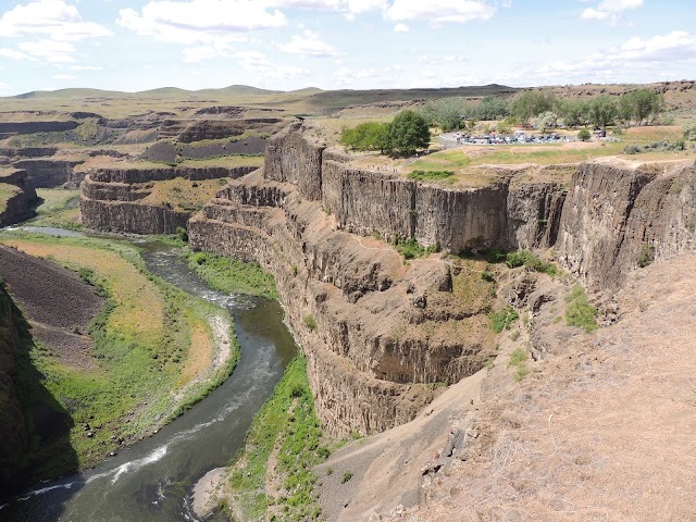
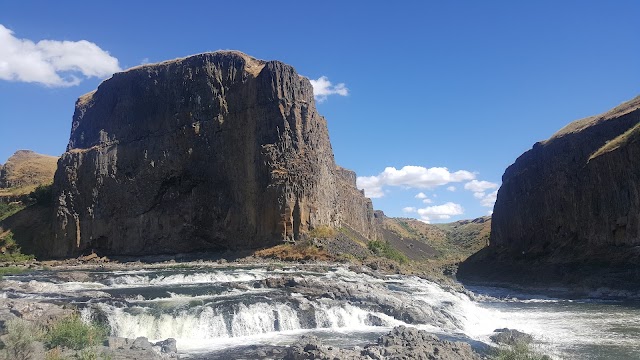
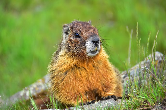
"Description: 📍 In Palouse Falls State Park, the Palouse River falls about 185 feet over the edge of a basalt cliff into a deep canyon. The canyon below the falls is marked by green moss and plants along the cliffs near the falls, as well as green riverine vegetation along the river banks, making a wonderful contrast with the black basalt and surrounding brown hills (or in spring, brown and green hills). The canyon below the falls is scenic on its own accord and would be worth a visit even without the falls. The canyon curves to the south just downstream from the falls. There is a campground perched on the western canyon rim. What to shoot While the falls are shaded at sunrise and sunset, if the clouds to the south or east light up, excellent photo opportunities await. To capture the falls and/or canyon at sunrise or sunset, you may want to use a split-neutral density filter to help control the contrast between the sky and the dark canyon below. Similarly, you may consider using HDR. You can shoot the falls directly from the official viewpoint near the parking lot and additional viewpoints south of the parking lot, but the down-canyon viewpoints along the canyon rim north of the parking lot provide (in my opinion) the best view - encompassing both the falls and the downstream canyon, which can be captured in a single shot. Be warned though, these viewpoints are right on the edge of vertical drop of at least 250 feet straight down to the canyon floor. This area is beyond the fence on the canyon rim near main viewpoint adjacent to the parking lot, and therefore, these unofficial viewpoints are not for those who are faint of heart or afraid of heights. The state park considers these viewpoints dangerous and posts danger warning signs along the trail north of the fence. If you do go to the down-canyon viewpoint, to place both the falls and downstream canyon both in single frame will require a wide-angle lens of about 18 mm or less (on a camera with a full-frame sensor). If you want an even wider angle or don’t have that wide a lens, consider stitching together a panorama using more than one shot. Normal to short telephoto lens work well to shoot the falls without including the canyon in your composition. A medium telephoto lens can be used to shoot details of the falls or canyon walls. It is possible to hike to the top of or bottom of the falls, though the trails are often steep, not maintained by the park, and definitely not recommended by the park rangers. if you do take one of these unofficial trails into the canyon, be extra careful. There is certainly no need to take these trails into the canyon to get good photographs, the views from the top of the canyon walls are spectacular. Marmots are active around the main falls viewpoints, and with patience, you can get rather close to take portraits of these groundhog relatives. The park is also home to many types of birds. The river flows year-round, but the biggest flows are in the spring. By late summer and fall, the flow is greatly diminished. The surrounding hills will be generally green in spring gradually changing to golden to brown in the summer. Winter may bring snow, and the canyon walls and plunge pool below the falls may be ice covered even without snow. The falls face west-southwest and receive direct sunlight in late morning through most of the afternoon during the spring. In the evening (or late afternoon depending on the season), the shadow of the canyon wall climbs up the falls, and before sunset, they are completely in shade. Similarly, the falls are completed shaded at sunrise. In Palouse Falls State Park, the Palouse River falls about 185 feet over the edge of a basalt cliff into a deep canyon. The canyon below the falls is marked by green moss and plants along the cliffs near the falls, as well as green riverine vegetation along the river banks, making a wonderful contrast with the black basalt and surrounding brown hills (or in spring, brown and green hills). The can Latitude: 46.66427777777780 Longitude: -118.22625000000000 Category: Waterfall"
@
"https://parks.wa.gov/find-parks/state-parks/palouse-falls-state-park-heritage-site"
@bbirdbrown
"Rolling hills della regione Palouse "
@
"Western and Northern Washington tend to grab all the attention, what with the massive national parks, beautiful coast, alpine villages, and goddamn Twin Peaks itself. But the eastern part of the state pulls its weight as well, and it takes one glance at Palouse Falls to see why. Here, the state reveals what appears to be a to-scale miniature version of the Grand Canyon, minus all the RV-bound tourists and plus a 200-foot waterfall dropping into an impossibly clear punchbowl. And at 94 acres, it's infinitely more explorable than that big-ass hole in the ground out in Arizona. Amazing Airbnb nearby: Hideaway Tent with Pool & Hot Tub"
@
"The top draw in the 94-acre Palouse Falls State Park in southeastern Washington is where the Palouse River crashes spectacularly over a ledge and into an Ice Age gorge chiseled from columnar basalt. It’s a 200-foot drop that sends clouds of mist billowing past its sheer rock walls—like something out of Jurassic Park. Though campgrounds are currently closed due to COVID-19, visitors have a choice of three distinct viewpoints, one of which is an ADA-compliant paved interpretive path."
@
"Washington’s official state waterfall. View from top of hiking trail is incredibly beautiful!"
@scottgurian
"Official waterfall of the state of WA"
@
"Looks like beautiful waterfalls in France's photos on Facebook"
@