
Vous pensez qu'il y a une erreur sur ce lieu ?
Signaler une erreur
Vos retours sont importants pour nous. Si vous avez remarqué une erreur concernant ce lieu, merci de nous en informer pour que nous puissions la corriger.
Propriétaire de ce lieu ?
Nous récupérons automatiquement les informations disponibles sur votre lieu. Si jamais celles-ci ne sont pas correctes, connectez-vous gratuitement sur notre tableau de bord pour les modifier et bonus, accédez à vos statistiques détaillées.
Ce qu'en disent les utilisateurs
Autres lieux à voir autour
 Lac Moraine
, District d'amélioration No 9, AB T0L, Canada
Ajouté par673 utilisateurs
Lac Moraine
Lac Moraine, District d'amélioration No 9, AB T0L, Canada
Ajouté par673 utilisateurs
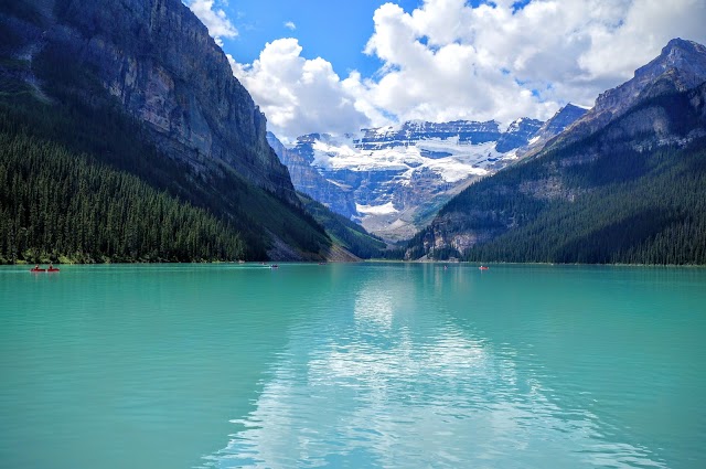 Lake Louise
, AB, Canada
Ajouté par370 utilisateurs
Lake Louise
Lake Louise, AB, Canada
Ajouté par370 utilisateurs
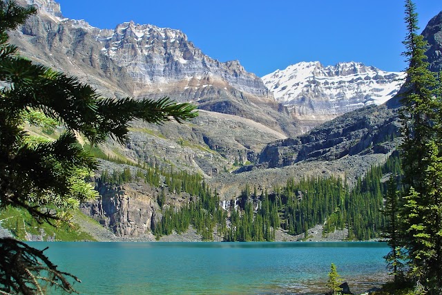
 Lac Emerald
, Columbia-Shuswap A, BC V0A, Canada
Ajouté par268 utilisateurs
Lac Emerald
Lac Emerald, Columbia-Shuswap A, BC V0A, Canada
Ajouté par268 utilisateurs
 Parc national du Canada Yoho
Field, BC V0A 1G0, Canada
Ajouté par179 utilisateurs
Parc national du Canada Yoho
Field, BC V0A 1G0, Canada
Ajouté par179 utilisateurs
 Lac Bow
, District d'amélioration No 9, AB T0L, Canada
Ajouté par148 utilisateurs
Lac Bow
Lac Bow, District d'amélioration No 9, AB T0L, Canada
Ajouté par148 utilisateurs
 Moraine Lake - View Point
622 Moraine Lake Rd, Field, AB T0L, Canada
Ajouté par148 utilisateurs
Moraine Lake-Banff National Park
Moraine Lake Rd Alberta T0L Canada
Ajouté par138 utilisateurs
Moraine Lake - View Point
622 Moraine Lake Rd, Field, AB T0L, Canada
Ajouté par148 utilisateurs
Moraine Lake-Banff National Park
Moraine Lake Rd Alberta T0L Canada
Ajouté par138 utilisateurs
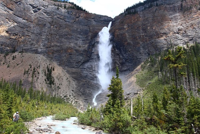 Chutes Takakkaw
Yoho National Park, BC V0A 1G0, Canada
Ajouté par130 utilisateurs
Chutes Takakkaw
Yoho National Park, BC V0A 1G0, Canada
Ajouté par130 utilisateurs
 111 Lake Louise Dr
, Lake Louise, AB T0L 1E0, Canada
Ajouté par129 utilisateurs
111 Lake Louise Dr
111 Lake Louise Dr, Lake Louise, AB T0L 1E0, Canada
Ajouté par129 utilisateurs
 Emerald Lake Lodge
1 Emerald Lake Drive, Field, BC V0A 1G0, Canada
Ajouté par115 utilisateurs
Emerald Lake Lodge
1 Emerald Lake Drive, Field, BC V0A 1G0, Canada
Ajouté par115 utilisateurs
"https://www.facebook.com/share/p/19LVDNVdxY/?mibextid=wwXIfr"
@
"Authentik Canada p38 et p54"
@bazinga.vp
"Découvert, à la fin du XIXe siècle, ce lac doit son nom à la couleur intense de ses eaux qui donne l’impression de voguer sur un diamant."
@
"https://www.instagram.com/reel/DCFGvQyR81J/?igsh=N2ppcnhqczhrbTRx"
@
"WHAT IS IT? One of only three known sites of Cambrian fossils. HOW TO GET THERE: By road. WHEN TO GO: All year round, but July to October for guided hikes to the fossil beds. NEAREST TOWN: Field, in the centre of the Park; Lake Louise 27 km (17 mi) DON'T MISS: Lake O'Hara YOU SHOULD KNOW: An entry fee is payable. Yoho National Park is the smallest of four national parks that together make up the Canadian Rocky Mountain Parks World Heritage Site. Located in south-eastern British Columbia on the western slopes of the Rocky Mountains, the park is a breath-taking region of snowy peaks - 28 of which are over 3,000 m (9,900 ft), glacial lakes, waterfalls, wild rivers and deep, dark forest. In 1909 Charles Walcott of the Smithsonian Institution, discovered a unique deposit of Cambrian era fossils here. Approximately 120 soft-bodied marine species from 515 million years ago have been found, perfectly preserved from the time when warm, shallow seas washed over land that has long since been uplifted to a major mountain range. These simple life forms took on bizarre shapes, and the fossils found in the Burgess Shale have provided scientists with a mass of new information about the evolutionary process itself. There are only two other known sites of these fossils in existence. These craggy mountains were a nightmare for the builders of the Canadian Pacific rail line, but resulted in two remarkable spiral tunnels, which climb up inside the mountain towards Kicking Horse Pass. The mighty river of the same name is responsible for having gouged out a natural bridge through solid rock, and water erosion has also formed hoodoos - boulders balanced on pillars of glacial debris. Glacial melt produces the amazing colour that gave Emerald Lake its name, the Takakkaw Falls is the third highest waterfall in the country and all these features are quite accessible either by car or by hiking some of the 400 km (250 mi) of very well maintained trails."
@
"une randonnée d'environ 5km autour du lac. il faut arriver tôt pour éviter la horde de touristes sentiers du lac Émeraude et des chutes Takakkam"
@